Skip to content
ABOUT
Close ABOUT
Open ABOUT
OUR MISSION
OUR CONSTITUTION
OFFICERS
Friends of
Mount Athos
NEWS & EVENTS
Close NEWS & EVENTS
Open NEWS & EVENTS
NEWS
EVENTS
Friends of
Mount Athos
VISITING
Close VISITING
Open VISITING
PILGRIMS GUIDE
DISCOVER THE MONASTERIES
CLIMBING THE MOUNTAIN
Friends of
Mount Athos
APPEALS
FOOTPATHS
Close FOOTPATHS
Open FOOTPATHS
FOOTPATH CLEARING PROJECT
FOLLOWING THE FOOTPATHS
DONATE
Friends of
Mount Athos
MEMBERSHIP
SHOP
Close SHOP
Open SHOP
BOOKS
CARDS
MAPS
MEMBERSHIP
Friends of
Mount Athos
£
0.00
0
Basket
User
Coins
Envelope
Search
Search
Popular Keywords
Categories
No Record Found
View All Results
Maps
£
0.00
0
Basket
Maps
Maps
£
22.00
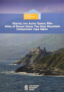
Mount Athos Pilgrim Map: Discover the Mysteries of the Holy Mountain
×
Donation
£
Donate to FoMA
Donate to Axion Estin Appeal
Donate to the Footpaths Project
Floods in Greece
Add Donation
Donation
Donation